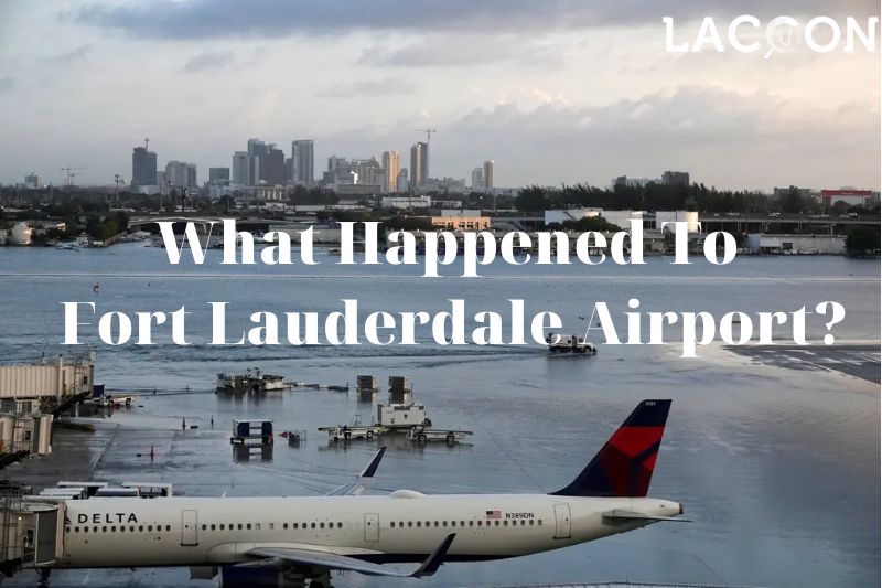
The Fort Lauderdale-Hollywood International Airport resumed operations after heavy rainfall and flooding caused widespread disruption across South Florida on April 14.
Heavy rain and flooding dumped several inches of water on the coast this week in just a few hours. Travel resumed Friday at Fort Lauderdale-Hollywood International Airport in soggy South Florida.
The airport reopened on Friday morning after being closed and canceling hundreds of flights on Wednesday and Thursday because of heavy rain.
Airport officials told travelers to check with their airlines before going to the airport, one of the busiest in Florida.
The stormy weather took down the Automated Surface Observing Systems at the Fort Lauderdale airport, run by the National Weather Service. As of Friday morning, analysts did not have the latest rainfall totals from the airport.
South Florida got heavy rain, gusty winds, and thunderstorms on Wednesday because of a storm that had never happened before.
What Happened To Fort Lauderdale Airport?

The Fort Lauderdale-Hollywood International Airport and the high-speed commuter train stopped working.
Cars struggled to navigate flooded roads in areas like North Bay Rd and 179th Dr. in Sunny Isles Beach, Fla.
As residents began draining streets and cleaning up after the storm, meteorologists predicted more showers and thunderstorms in South Florida on Friday.
Flood warnings ended in the middle of the morning on Friday, but the weather service still told cars to be careful on flooded roads.
Even though it rained, there was no change to the plans for the Tortuga Music Festival on Fort Lauderdale Beach this weekend.
The organizers said the three-day event to raise knowledge about ocean conservation will start as planned on Friday afternoon.

South Florida was hit by a rare and very heavy rainstorm less than two months before the Atlantic hurricane season began on June 1. Bill Deger, a senior meteorologist at AccuWeather, said, “It’s probably even worse than what we’d see in a hurricane.”
Deger said that it is rare for one place to get 4 to 6 inches of rain per hour for several hours. He called the bad weather event “almost the perfect storm.”
Deger said that the thunderstorm complex kept forming over the same area and didn’t move much over many hours. This was partly because there wasn’t much wind in the area, which is what would usually move these storms around.
“So you could say it was even bigger than what you would see in the worst hurricane,” he said.
Broward County Public Schools has a lot of students – over 256,000! It is actually the sixth-biggest school district in the whole country.
Unfortunately, because of the big storm, some of the schools had water in the halls and classrooms. That’s why they had to cancel classes again on Friday. Thursday was the last day of school anyway.
So, on Friday, all of the district schools and offices were going to be closed, including after-school and extracurricular programs.
The district said this in a tweet. They also said that the schools and executive offices should be open again on Monday, April 17th.
Several factors aligned in just the wrong way, resulting in a rainmaker virtually stalling over Fort Lauderdale for hours.
Winds from two different directions came together ahead of and along the front. This brought moist air and made slow-moving thunderstorms along the coast and offshore.
The different weather trends worked together in a way that is hard to predict on a local level.
As the warm front moved north, storms kept getting worse and dumped huge amounts of rain on Broward County.
South Florida was expected to get more rain and thunderstorms on Friday, but a Miami-based weather service meteorologist, Donal Harrigan, said it was possible that the wet weather would hit places farther north, away from Fort Lauderdale and the coast.
Harrigan said some of the models indicated that the potential rainfall amounts would be less than on the previous days, but any rainfall over there could still be pretty impactful considering that some roads are still closed.
“There probably wouldn’t be long-term problems, but it could lead to short-term road closures in those areas,” Harrigan said, adding that flash floods were not expected to be an emergency on Friday.
The situation was further exacerbated by Florida Governor Ron DeSantis’s absence from the state during the flooding crisis.
Donald Trump Jr. criticized DeSantis’s lack of presence, tweeting, “Fort Lauderdale is underwater and DeSantis is campaigning in Ohio right now instead of taking care of the people suffering in his state.”

After his book tour stop in Ohio on Thursday, On Friday, DeSantis was supposed to give a speech to Republican donors in New Hampshire. Broward County is in a state of emergency because of the heavy flooding on Thursday.
In the end, this week’s unusually heavy rain and flooding in South Florida caused a lot of trouble all over the area.
The storm hit a lot of places, but the Fort Lauderdale-Hollywood International Airport was hit the hardest.
The rain turned the runways and approach roads into rivers, which meant that hundreds of flights had to be canceled and the airport had to close.
The stormy conditions also knocked the Fort Lauderdale airport’s National Weather Service-operated Automated Surface Observing Systems offline, making it difficult to monitor the situation accurately.
The situation was further compounded by Governor DeSantis’s absence from the state during the flooding crisis, leading to criticism from Donald Trump Jr.
Despite the challenging circumstances, the residents of South Florida showed resilience and continued to carry on with their activities.
The Tortuga Music Festival, a three-day festival for ocean conservation awareness, went ahead as planned, and plans for other events and activities also continued.
The time for big storms in the Atlantic starts on June 1st, so the area is getting ready for it.
This week’s big storm emphasized the significance of being ready for severe weather conditions and having strategies to deal with them. Being ready for big storms like this is really important in case they happen again.